
How to Drive on Iceland’s F-Roads
A Guide to Iceland’s F-Roads
Iceland's F-roads (Fjallvegir, meaning 'mountain roads') are unpaved highland routes that provide access to some of the country's most remote and spectacular landscapes. These challenging roads require proper preparation, a capable 4x4 vehicle, and an understanding of unique driving conditions, including river crossings, loose gravel, volcanic terrain, and rapidly changing weather.
If you only have a few days in Iceland, making the absolute most of your limited time is your first priority. The Highlands are often a goal for the more adventurous travelers, but Iceland's F-Roads are a mystery for many.
For those who may not be aware of Iceland's Highland routes, the area's network of gravel roads, known as F-Roads, can be difficult to navigate, as they often contain loose gravel and unpredictable terrain. We have put together a comprehensive guide for drivers who are new to F-Road driving, as well as a trusty F-Roads of Iceland map, so that you can enjoy the scenery without putting your safety at risk.
Iceland's F-Roads provide access to the breathtaking and remote Highlands, offering an unforgettable adventure for those prepared to tackle the challenges. To navigate these rugged Icelandic Highland roads safely, it's essential to plan ahead and drive responsibly.
Here's everything you need to know:

What Are Iceland's F-Roads?
F-Roads (designated by the prefix 'F' followed by a route number) are Iceland's Highland mountain roads that traverse the country's uninhabited interior plateau.
The designation “F” comes from “Fjallvegir” (mountain roads in Icelandic). These unpaved routes cross volcanic deserts, glacial rivers, and mountain passes at elevations typically between 400 and 500 meters above sea level.
Key characteristics of F-Roads include:
- Unpaved gravel or dirt surfaces with loose stones
- Unbridged river crossings (some requiring water depths up to 50cm)
- Steep gradients and sharp switchbacks
- No cellular coverage in most areas
- Minimal to no roadside services or facilities
- Seasonal access only (typically mid-June to early September)
F-Roads are roads that access the Highlands of Iceland and are infamous for their taxing conditions, with rough terrain and bad weather common in these more remote parts of the country. It's for this reason that we recommend doing your research or avoiding these F-Roads altogether, especially if you're not a confident driver.
What Are Iceland's Highlands?
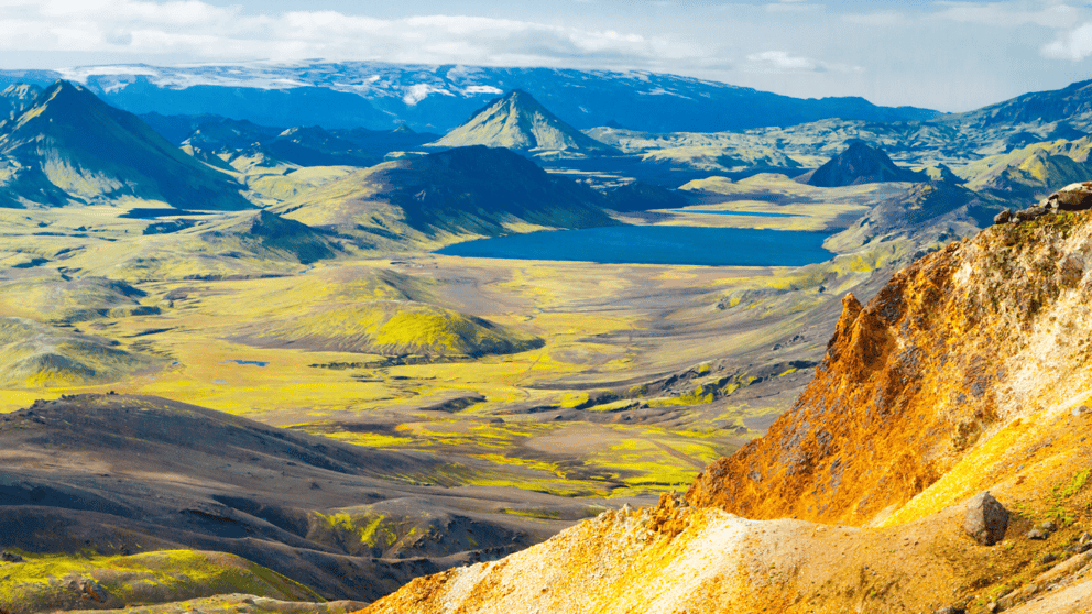
The Highlands of Iceland cover the majority of the inland area of the country. Situated around 400-500 meters above sea level, this volcanic desert is almost entirely devoid of human life and vegetation. The ground here is mostly volcanic ash and dirt. There are some sparse, oasis-like locations around the Highlands, but they are few and far between.
The Icelandic Highlands constitute approximately 40% of Iceland's total land area, encompassing roughly 40,000 square kilometers of uninhabited wilderness.
This stark volcanic plateau was formed by millennia of volcanic activity and glacial erosion, creating a unique landscape of black sand deserts, colorful rhyolite mountains, active geothermal areas, and pristine glacial rivers.
What Vehicle is Required for Traveling the F-Roads?
Icelandic law (Traffic Law Article 50) mandates that only four-wheel-drive (4WD or 4x4) vehicles with high ground clearance may access F-Roads. This requirement exists because:
- River crossings require sufficient ground clearance to prevent water from entering the engine air intake
- Loose gravel and deep ruts demand 4WD traction to maintain control
- Rocky terrain can damage undercarriage components on low-clearance vehicles
- Steep inclines on loose surfaces require low-range gearing
To take on Iceland's F-Roads, an SUV with 4-wheel drive is essential. Iceland's Highlands offer immense natural beauty but are untamed. The tracks can often be complicated to drive on, so it is important that you have a sturdy 4x4 vehicle to take you safely across the roads. Some of our most popular 4x4 models include:

Recommended specifications for F-Road vehicles:
- Minimum ground clearance: 20cm (higher is better for river crossings)
- 4WD system with a low-range transfer case preferred for steep climbs
- All-terrain tires with an aggressive tread pattern
- Underbody protection (skid plates for engine, transmission, fuel tank)
- Adequate fuel tank capacity (many routes exceed 200km between fuel stations)
This is mandatory by Icelandic law, so ensure you are prepared with a suitable rental car before venturing onto F-Roads. Most F-Roads will have the following road sign at the entrance to warn you of this restriction.
Important: Rental car insurance typically does not cover damage from river crossings or off-road driving. Always verify coverage details before attempting F-Road travel.
When Are Iceland's F-Roads Open?
F-Road opening dates vary annually based on snowmelt, road conditions, and weather patterns. The Icelandic Road and Coastal Administration (Vegagerðin) conducts thorough assessments before opening each route.
Typical opening schedule:
- Early opening routes (mid-June): F35 Kjölur, F550 Kaldidalur
- Mid-season opening (late June to early July): F26 Sprengisandur, F208/F210 to Landmannalaugar, F249 to Þórsmörk
- Late opening routes (mid to late July): F88 to Askja, F910 (Austurleið)
- Typical closing: Early to mid-September (weather dependent)
Due to weather conditions, F-Roads are only open for a short period of time. Most of the roads are open during the summertime, anywhere between June and September.
When F-Roads are opened for the season, they are assessed for snow on the roads and the level of damage. In order to open the roads, they need to be in good condition to withstand future driving. Always check the latest travel info pertaining to Iceland's F-Roads.
Critical: F-Roads can close suddenly due to weather events (snowstorms, flooding, volcanic activity). Check road.is daily during your trip and be prepared to alter plans. Attempting to access closed F-Roads is illegal and extremely dangerous.
Is There a Map of Iceland's F-Roads?
Yes! As you can see from the F-Roads of Iceland map we have shared below, there are a number of Highland routes in Iceland. The most well-known roads are:
- F35 Kjölur
- F26 Sprengisandur
- F208 Fjallabaksleið Nyrðri
It's important to take an F-Roads map with you when you are traveling in Iceland's Highlands. You should also check conditions regularly when your mobile signal allows you to do so. If you know you are planning to travel on a variety of F-Roads throughout your trip, you can visit Road.is to find their very helpful F-Roads map. It also shows live coverage of the conditions of all the roads in Iceland. This will help you travel safely on the F-Roads and beyond.
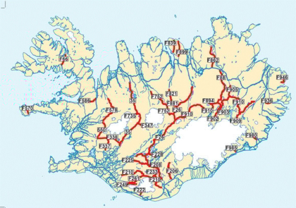
Map from Road.Is
When are Iceland’s F-Roads Open?
Due to weather conditions, F-Roads are only open for a short period of time. Most of the roads are open during the summertime, anywhere between June and September. When F-Roads are opened for the season, they are assessed for snow on the roads and the level of damage. In order to open the roads, they need to be in good condition to withstand future driving. Always check the latest travel info pertaining to Iceland’s F-Roads.
When is the Best Time to Travel the Highlands?
Due to the above, the best time to travel in the Highlands would be the summer months. It is important to keep in mind the unpredictability of the seasons in Iceland. The weather can be bad enough that some roads only officially open in late July, and winter arrives at unpredictable dates as well, leading to potentially unexpected or early closures.
What Should I Know Before Driving the F-Roads?
If you’re confident about taking on the adventure of driving on the F-Roads in Iceland, there are some things to consider before and during your time in the Highlands.
Check Beforehand: Even if you know that F-Roads are open, be sure to regularly check the Icelandic weather forecast and predicted road conditions.
Be Confident: Get to know your vehicle and ensure that you are confident enough. It is imperative that your car is a 4x4, but you will also need to know how to handle it properly. Ask the staff when you pick up your car for more information.
Limit Your Speed: It is important that you limit your speed when driving F-Roads. They can be complicated to navigate, so do not rush and take your time.
Avoid Rivers: Heavy rain can raise river levels immediately, so crossing rivers is incredibly dangerous. We suggest completely avoiding crossing high water levels. Also, you should never cross a river where the water is still, as this could be a deep area.
Essential Mapping Resources:
- Road.is – Official road conditions and closures (updated daily)
- Vedur.is – Weather forecasts specific to highland regions
- SafeTravel.is – Registration service to inform authorities of your travel plans
- 112 Iceland app – Emergency services app with offline location sharing
What Are the Most Popular F-Roads?
One of the most popular locations, only accessible via F-Roads, is Landmannalaugar. There are 3 main routes to take; F208 is by far the easiest and is accessible by most 4x4s. The second is the F225, which requires a larger 4x4, such as a Toyota RAV4. There are also F26 and F206, which are completely inaccessible unless you are in a fairly raised vehicle. Here is a list of all of the main F-Roads:

Detailed F-Road descriptions with difficulty ratings:
F35 Kjölur (Easiest – Beginner Friendly)
- Distance: 170km from Gullfoss to Blönduós
- River crossings: 2-3 shallow crossings (typically <30cm)
- Highlights: Hveravellir geothermal area, Langjökull glacier views
- Best for: First-time F-Road drivers, accessible mid-June through September
F26 Sprengisandur (Moderate)
- Distance: 220km crossing the central highlands
- River crossings: Multiple crossings, including the challenging Tungnaá river
- Highlights: Stark volcanic desert, total isolation, Vatnajökull views
- Best for: Experienced highland drivers, typically accessible July-August
F208/F210 to Landmannalaugar (Moderate)
- Distance: 50km from Ring Road via F208 (shortest route)
- River crossings: F208 has 2-3 moderate crossings; F225 has deeper crossings
- Highlights: Rainbow rhyolite mountains, natural hot spring, hiking trails
- Best for: Most 4x4 vehicles via F208; larger vehicles required for F225 route
F88 Öskjuvegur to Askja (Challenging)
- Distance: 85km from Ring Road to Askja caldera
- River crossings: Several challenging crossings, including Lindaá and Grafarlandaá
- Highlights: Askja caldera, Víti crater lake, moon-like landscapes (Apollo training site)
- Best for: Experienced drivers with a capable 4x4, typically accessible late July-August
F249 to Þórsmörk (Challenging)
- Distance: 40km from the Seljalandsfoss area
- River crossings: Multiple glacial river crossings, including deep and fast-flowing Krossá
- Highlights: Thor's Valley, dramatic glaciers, lush vegetation, Laugavegur trail access
- Best for: Very experienced drivers only; consider a Super Jeep tour as an alternative
F550 Kaldidalur (Easy)
- Distance: 40km connecting Þingvellir and Borgarfjörður
- River crossings: None (making it one of the easiest F-roads)
- Highlights: Views between Langjökull and Þórisjökull glaciers, historic route
- Best for: F-road beginners, families, early season access (often opens mid-June)
Here is a comprehensive list of the main F-Roads:
- F26 – Sprengisandur/Sprengisandsleið - Hrauneyjar - Nýidalur
- F26 – Sprengisandur/Sprengisandsleið - Nýidalur - Bárðardalur
- F35 – Kjölur - Gullfoss - Hveravellir
- F35 – Kjölur - Hveravellir - Blonduvirkjun
- F88 – Öskjuvegur - To Herdubreidarlindir
- F225 – Landmannaleið
- F550 - Kaldidalur
Preparation Checklist
Exploring F-Roads in Iceland requires careful preparation:
Choose a suitable vehicle: Only 4x4 vehicles are permitted on Iceland's F-Roads, as the rugged terrain demands extra power and ground clearance.
Inform someone of your plans: Share your itinerary with a friend, family member, or local contact so someone knows your whereabouts. Use safetravel.is to register your travel plan with Icelandic authorities.
Bring a detailed map: A physical F-Roads Iceland map is essential, as mobile GPS can be unreliable in the highlands. Download offline maps (Maps.me, Google Maps offline) before departure.
Check road conditions: Visit road.is for real-time updates on Iceland highland roads, including closures or hazards.
Pack essential emergency supplies:
- Extra food and water (minimum 3 liters per person)
- Warm clothing and waterproof layers (hypothermia risk even in summer)
- First aid kit and any required medications
- Fully charged portable phone battery/power bank
- Flashlight or headlamp with extra batteries
- Basic tools: jack, spare tire, tire pressure gauge, tow strap
- Emergency blanket or sleeping bag
- Satellite communicator or emergency beacon (recommended for solo travel)
What Driving Tips Should I Be Aware of in the Highlands?
Driving Tips
Navigating the challenging terrain of Iceland's F-Roads requires caution and attention:
Travel in groups if possible: Driving in tandem with another vehicle is safer in case of emergencies. If one vehicle gets stuck or breaks down, the other can provide assistance or fetch help.
Drive carefully: Gravel roads can be slippery, and wet conditions can make certain areas unstable. Keep your speed low and remain vigilant. Recommended maximum speed: 30-40 km/h on most F-Roads, slower on rough sections.
Approach river crossings with care: Many F-Roads in Iceland require crossing rivers, which can be hazardous. Assess the depth and flow before crossing, and avoid taking risks.
River crossing detailed protocol:
- Scout on foot: Walk the crossing to find the shallowest route (usually the widest point, diagonal crossing)
- Check depth: Use a stick or rock to gauge depth. Max safe depth is typically 50cm, but varies by vehicle
- Cross in the morning: Glacial meltwater is lowest in early morning, highest in late afternoon/evening
- Engage 4WD low range: Use the lowest gear, maintain a steady speed (5-10 km/h)
- Create a bow wave: Enter at an angle to the current, steady momentum creates a water-deflecting bow wave
- Never stop mid-crossing: Maintain momentum; stopping allows water to enter the engine bay
- Avoid calm water: Still water indicates deep pools; look for rippled water showing a shallow bottom
- If uncertain: Wait for another vehicle to cross first, or turn back. No destination is worth vehicle loss.
Additional advanced driving techniques:
- Tire pressure management: Slightly reducing tire pressure (to 1.8-2.0 bar) improves traction on sand/gravel, but remember to re-inflate
- Loose gravel technique: Avoid sudden steering inputs; use gentle, progressive movements
- Steep descents: Use engine braking (low gear) rather than brakes to prevent skidding
- Oncoming vehicles: Slow down significantly and move to the right edge; gravel flies from tires at speed
Emergency Preparedness
Mobile signal is often limited on Iceland's Highland roads, so it's vital to be prepared for emergencies. Remember that Iceland's emergency number, 112, can be dialed even without a mobile connection. Download the 112 Iceland app before your trip – it shares your GPS location with rescuers even without a cell signal.
What to do if stranded or stuck:
- Stay with your vehicle: It provides shelter and is easier for rescuers to spot than a person.
- Call 112 immediately: Even without a signal, emergency calls may connect via any available network.
- Use the 112 app: Share location via the app if it connects.
- Create visibility: Use bright clothing, reflective materials, or vehicle hazard lights.
- Conserve fuel: Run the engine intermittently for heat rather than continuously.
- Wait for help: Iceland's rescue teams are highly professional; they will find you if you've registered your route.
Fuel Availability
Fuel stations are scarce in the Highlands, with only one located at Hveravellir. Be sure to refuel before heading onto remote Iceland F-Roads to avoid being stranded.
Fuel planning essentials:
- Calculate fuel requirements: Highland driving consumes 30-50% more fuel than highway driving due to low gearing and 4WD.
- Hveravellir station: Only highland fuel source, located on the F35 Kjölur route. Credit card only, no cash accepted.
- Carry extra fuel: Use approved jerry cans (20L recommended) for extended routes like F26 Sprengisandur (220km).
- Plan fuel stops: Start every F-road with a full tank. Know the distance to the next fuel and your vehicle's range.
Protecting the Environment
Off-road driving in Iceland is strictly prohibited to protect the fragile ecosystem. Always stay on marked trails and designated roads to ensure the safety of the environment and yourself.
Leave No Trace principles for Highland travel:
- Never drive off-road: Iceland's volcanic soil is extremely fragile. Tire tracks can remain visible for decades, and damage takes centuries to heal. Off-road driving carries heavy fines (up to 1,000,000 ISK).
- Pack out all waste: Including toilet paper and organic waste. Use designated facilities or pack waste out in sealed bags.
- Stay on marked paths: When parking or camping, use only designated areas. Don't create new paths or campsites.
- Respect wildlife: Maintain distance from nesting birds (especially ground-nesting species), don't feed animals.
- Minimize noise: Keep vehicle noise low, respect the wilderness experience for others.
- Use official toilets: Never toilet within 50m of water sources. Use facilities at Hveravellir and other designated stops.
When is the Best Time to Travel the Highlands?
Due to the above, the best time to travel in the Highlands would be the summer months. It is important to keep in mind the unpredictability of the seasons in Iceland. The weather can be bad enough that some roads only officially open in late July, and winter arrives at unpredictable dates as well, leading to potentially unexpected or early closures.
Optimal timing by month:
- June: Early routes open (F35, F550), longer daylight hours begin, fewer crowds, snowmelt makes rivers higher
- July: Peak season, most F-Roads open, warmest temperatures (10-15°C highlands), midnight sun provides 24h daylight, busiest period
- August: All routes accessible, slightly cooler, autumn colors begin, rivers at their lowest levels (best for crossings), fewer tourists than in July
- September: Early closures possible, dramatic weather changes, significantly fewer visitors, northern lights may appear, only experienced drivers should attempt
Does My Route Contain an F-Road?
Due to the confusing nature of F-Roads, many travelers tend to wonder if their route contains F-Roads. In most cases, it does not. A large number of visitors tend to stick to popular routes such as the Golden Circle, the South Coast, and Iceland's Ring Road. These routes are easy to navigate and do not contain F-Roads. Always check your route ahead of time, and feel free to reach out to us when you collect your rental car. We can let you know if you'll encounter any F-Roads.
Common routes that do NOT require F-Roads:
- Ring Road (Route 1): Complete circuit of Iceland, all paved, accessible to all vehicles
- Golden Circle: Þingvellir, Geysir, Gullfoss - entirely on standard roads
- South Coast: Seljalandsfoss, Skógafoss, Reynisfjara, Jökulsárlón - no F-Roads required
- Snæfellsnes Peninsula: Kirkjufell, Djúpalónssandur - accessible without 4x4
- Diamond Circle (North): Dettifoss, Ásbyrgi, Húsavík - mostly standard roads (Route 862 to Dettifoss requires 4x4 but isn't an F-Road)
Are F-Roads Worth It? What Can I See?
Iceland has a surprise in store around every corner, and this is especially true in the more remote areas of the country. There are many beautiful locations to see in the Highlands, and chances are you will be one of the few people there. In fact, many places you visit in the Highlands will be empty of any other tourists at all! The Highlands are home to the best-kept secrets of the country, and F-Roads are often the best way to explore these to your heart's content.
Landmannalaugar is famous for its colorful, picturesque landscape and geothermal pool, which is a popular tourist attraction. The pool and surrounding area are easily accessible from Reykjavik for a day trip. Askja is the caldera of a volcano in Iceland, which last erupted in 1875, leaving behind a striking deep blue lake. Close by is the Víti crater, which is a popular geothermal bath among bathing enthusiasts, although it can get quite hot.
Unique Highland attractions accessible only via F-Roads:
Landmannalaugar (F208/F224/F225):
- Rainbow-colored rhyolite mountains (reds, yellows, greens, blues)
- Natural geothermal bathing pool
- Laugavegur hiking trail terminus (Iceland's most famous multi-day trek)
- Lava fields and obsidian flows
Askja Caldera & Víti Crater (F88):
- Massive volcanic caldera formed by the 1875 eruption (one of Iceland's largest eruptions)
- Víti crater lake (milky blue geothermal water, warm enough for swimming)
- Öskjuvatn lake (the deepest lake in Iceland at 220m)
- Lunar-like landscape (NASA Apollo astronauts trained here)
Other Highland Highlights:
Hekla Volcano: A hiker's paradise and one of the most active volcanoes in the world. Known as 'Gateway to Hell' in medieval times, it last erupted in 2000.
Þórsmörk: Home to mind-blowing scenery and mountain ridges, as well as an iconic Icelandic trekking route. Sheltered valley between three glaciers: Tindfjallajökull, Eyjafjallajökull, and Mýrdalsjökull.
Langisjór Lake: Views over this huge natural lake are the cherry on top of any hike! A 20km-long glacial lake surrounded by stark volcanic landscapes, accessible via F235.
Hveravellir (F35 Kjölur):
- Active geothermal area with bubbling mud pots and steaming fumaroles
- Natural hot springs for bathing
- Only a Highland service station (fuel, toilets, simple accommodations)
- Historic outlaw hideout from the 17th century
Value comparison: Self-drive F-Road adventure vs. guided tours:
Self-drive advantages:
- Complete flexibility in timing and route
- Ability to explore at your own pace, stop anywhere
- Generally more cost-effective for 2+ people
- Sense of adventure and accomplishment
Guided tour advantages:
- Expert drivers handle challenging crossings and navigation
- Super Jeep vehicles access extremely difficult routes (F249 to Þórsmörk)
- Local knowledge and geological/historical context
- No risk to rental vehicle or insurance concerns
By following these tips, you can confidently navigate Iceland's stunning Highland roads and enjoy an unforgettable journey through the heart of the country's rugged landscapes.
All that's left now is to book your 4x4 with Iceland Car Rental and start your adventure. Explore Iceland car rental your way.